Wednesday, May 20, 2015

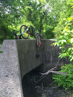
#419 Bedford Park Blvd. West Overpass over the Jerome Avenue Train Yard


Bedford Park Blvd. West Overpass over the Jerome Avenue Train Yard
May 20, 2015, Sophie Lrits, Keith Nelson, Rob Hickman

View on Unicycle NYC Bridge Tour Map at: unibridgetour.net

ride time: 4:21:09
distance: 14.51 miles
ride link

#418 Bridgeway entrance to Lehman College Art Gallery


Bridgeway entrance to Lehman College Art Gallery
May 20, 2015, Sophie Lrits, Rob Hickman, Keith Nelson

View on Unicycle NYC Bridge Tour Map at: unibridgetour.net

#417 Cross Campus Bridgeway at Lehman College


Cross Campus Bridgeway at Lehman College
May 20, 2015, Sophie Lrits, Rob Hickman, Keith Nelson

View on Unicycle NYC Bridge Tour Map at: unibridgetour.net

#416 Entryway Bridge at Bronx High School of Science


Entryway Bridge at Bronx High School of Science
May 20, 2015, Sophie Lrits, Rob Hickman, Keith Nelson View on Unicycle NYC Bridge Tour Map at: unibridgetour.net

#415 Van Cortlandt Park South Overpass over Major Deegan Expy I-87


Van Cortlandt Park South Overpass over Major Deegan Expy I-87
May 20, 2015, Keith Nelson, Sophie Lrits, Rob Hickman

#414 Van Cortlandt Park South Overpass over Putnam Trail (former New York and Putnam Railroad line)


Van Cortlandt Park South Overpass over Putnam Trail (former New York and Putnam Railroad line)
May 20, 2015, Keith Nelson, Rob Hickman, Sophie Lrits

#413 Putnam Trail overpass (former New York and Putnam Railroad line)


Putnam Trail overpass (former New York and Putnam Railroad line)
May 20, 2015, Keith Nelson, Rob Hickman, Sophie Lrits

#412 John Kieran Nature Trail Bridge #3, Van Cortlandt Park


John Kieran Nature Trail Bridge #3, Van Cortlandt Park
May 20, 2015, Sophie Lrits, Rob Hickman, Keith Nelson

#411 Van Cortlandt Golf Course Trail Bridge


Van Cortlandt Golf Course Trail Bridge
May 20, 2015, Keith Nelson, Rob Hickman, Sophie Lrits

#410 Van Cortlandt Golf Course Trail Bridge (former New York and Putnam Railroad line)


Van Cortlandt Golf Course Trail Bridge (former New York and Putnam Railroad line)
May 20, 2015, Keith Nelson, Rob Hickman, Sophie Lrits

View on Unicycle NYC Bridge Tour Map at: unibridgetour.net

From Wikipedia:

The New York and Putnam Railroad (a.k.a. Old Put) was a railroad line that operated between The Bronx and Brewster, New York. It was in close proximity to Hudson River Railroad and New York & Harlem Railroad. All three came under ownership of the New York Central system in 1894. Abandonment began in 1958; most of the former roadbed has been converted for rail trail use.

The New York & Boston Railroad (NY&B) was chartered May 21, 1869 to build a line from High Bridge on the Harlem River in New York northeast to Brewster. At Brewster connections were to be provided to the New York & Harlem Railroad for travel north to Albany, and to the Boston, Hartford & Erie Railroad to Boston.

New York Central's Putnam Division, Getty Square branch Southbound (Eastbound) electric schedules from Employee Timetable No. 55 effective 1942-06-07 showing service operated few years before abandonment.

The New York, Boston & Northern Railway (NYB&N) was formed on November 18, 1872 as a consolidation of the NY&B with two companies to the north — the Putnam & Dutchess Railroad (P&D) and Dutchess & Columbia Railroad (D&C). The P&D was a plan for a line to split from the New York and Boston at Carmel to a point midway along the D&C. The D&C opened in 1871, running from the Hudson River to the Connecticut border. The Clove Branch Railroad was to serve as a short connection between the two parts of the planned line.

The New York, Boston & Montreal Railway was organized January 21, 1873 as a renaming of the NYB&N. It continued north to Chatham and then use the Harlem Extension Railroad into Vermont. The Panic of 1873 caused the cancellation of the leases and mergers on December 1 of that year. Construction on the P&D and D&C stopped; D&C later became part of the Central New England Railway, the Harlem Extension became a part of the Rutland Railroad, and the Clove Branch Railroad was abandoned in 1898.

The New York, Westchester & Putnam Railway was formed on July 3, 1877 as a reorganization, and was leased to the New York City & Northern Railroad (NYC&N), formed on March 1, 1878. Between East View and Pocantico Hills, the NYC&N built a segment leading to a perilous 80 foot high trestle over a marsh-filled valley. Because of the dangers of crossing the bridge, which often required that trains slow down to a crawl, the line was rerouted west around that valley in 1881. The bridge was torn down in 1883, and the valley became the Tarrytown Reservoir. The line finally opened under the original plan, ending at Brewster, in April 1881. That year, the New York & New England Railroad opened to the north, using some of the grade built for the P&D and D&C. The West Side & Yonkers Railway was leased to the NYC&N on May 1, 1880, extending the line south across the Harlem River to the northern terminal of the Ninth Avenue Elevated at 155th Street. It was merged into the NYC&N by 1887. In the 1910s, the Interborough Rapid Transit Company of the New York City subway (IRT) purchased that section its elevated lines north into the Bronx, cutting the NYP back to Sedgwick Avenue. The Yonkers Rapid Transit Railway was opened in 1888 as a branch from the NYP at Van Cortlandt northwest to Yonkers. It was merged into NYP by 1887.

The company went into receivership by 1887 and was reorganized as the New York & Northern Railway. By 1894 it was reorganized as the New York & Putnam Railroad (NY&P) by J. P. Morgan who in turned leased the railroad to the New York Central & Hudson River Railroad (NYC&HR). The line eventually became the Putnam Division of the New York Central Railroad (NYC) by 1913. The line lacked a direct connection to NYC's flagship station, Grand Central Terminal (GCT), which hurt ridership throughout its existence. Passengers were forced to transfer at High Bridge to reach GCT. The Sedgwick Avenue-Van Cortlandt section and the Yonkers Branch were electrified in 1926.

Several short branches were eliminated after the 1920s. The Mohansic Branch near Yorktown Heights, originally built to serve a mental institution that was cancelled by Albany, went first. In 1929, John D. Rockefeller, Jr. had the tracks removed from his Pocantico Hills property, eliminating four stations and creating a single one. The nearby village of East View was obliterated to build the new line. The Getty Square branch was abandoned on June 30, 1943. Despite a legal battle by Yonkers residents which reached the United States Supreme Court to save it, the line was scrapped in December 1944.

The first diesel locomotive passenger train in the U.S. ran on the Putnam on March 18, 1929.

Besides the regular Sedgwick Avenue–Brewster service, service also operated from Golden's Bridge on the Harlem Division via a connecting branch to Lake Mahopac, and then over the Putnam Division to Brewster, where it returned to the Harlem Division. Trains taking this route were said to go "around the horn".

NYC saw the Putnam Division as a dispensable stepchild. The line lacked a second track, electrification, commuter parking and direct service to GCT, all of which the parallel Harlem and Hudson divisions had, resulting in steady patronage. NYC ended passenger service on the Putnam on May 29, 1958. Service "around the horn" via the Harlem Division's Lake Mahopac Branch continued until April 2, 1959. Until 1962, when NYC's West Shore Railroad was upgraded, the Putnam served oversize freight trains, due to the lack of tunnels on the line. Tracks between East View and Lake Mahopac were removed in 1962.

NYC merged with long-time rival Pennsylvania Railroad to form the Penn Central (PC) in 1968. Freight service on the northern part of the Putnam ended by 1970. The southern end of the line remained in service until the closing of the A&P warehouse in Elmsford in 1975. The decrease in traffic from Stauffer Chemical cut back the line to Chauncey by 1977. Conrail took over the bankrupt PC in April 1976, but had no plans for increasing business. Aside from occasional movements to Chauncey, the only customer was the Stella D'Oro bakery in the Bronx.

Metro-North currently uses the remaining stub at Marble Hill ("BN") for storage of maintenance of way and contractor's trains. The roadbed north of the former Van Cortlandt station has been converted into the South County Trailway, North County Trailway, and Putnam County Trailway rail trails.

A replica of the former Bryn Mawr Park station at the former Palmer Road grade crossing is in use as a grocery. The station in Briarcliff Manor was purchased by the village in 1959 and converted into a the Briarcliff Manor Public Library. The station in Elmsford serves as a restaurant. The Yorktown Heights station had its exterior restored and is the centerpiece of the town park. The station in Lake Mahopac has been an American Legion Hall since 1965. The freight house in Baldwin Place and the station in Tilly Foster are on private property.

The Getty Square Branch still shows evidence of its existence, with vestiges of the railroad and stations, and neighborhoods exhibiting characteristics of transit-oriented development. Getty Square station, originally a head house and train shed, was replaced by an office building, which still stands and is ornamented on its exterior and in its lobby with images of locomotives. The bridge in Van Cortlandt Park that carried the branch over the Henry Hudson Parkway is now a multi-use park path.

Abutments of the former branch can be found at School Street across from Herriott Street, McLean Avenue near South Broadway, and the former Lowerre Station on Lawrence Street at Western Avenue. The former Caryl Station on Caryl Avenue between Saratoga and Van Cortlandt Park Avenues, with the tunnel into Van Cortlandt Park walled off by cinder blocks is now the Caryl parking lot and playground.

Private homes that once served the branch include the termini houses of the Park Hill station's adjacent Incline railway (funicular) on Undercliff at Park Hill Terrace, and on Alta Avenue north of Overcliff, and the home of the railroad's president also on Alta Avenue.

#409 Small Wooden Bridge off Old Putnam Trail, Van Cortlandt Park


Small Wooden Bridge off Old Putnam Trail, Van Cortlandt Park
May 20, 2015, Rob Hickman, Keith Nelson, Sophie Lrits

#408 John Kieran Nature Trail Bridge #2 over Van Cortland Lake, Van Cortlandt Park


John Kieran Nature Trail Bridge #2 over Van Cortland Lake, Van Cortlandt Park
May 20, 2015, Keith Nelson, Sophie Lrits, Rob Hickman

#407 John Kieran Nature Trail Bridge over Van Cortland Lake, Van Cortlandt Park


John Kieran Nature Trail Bridge over Van Cortland Lake, Van Cortlandt Park
May 20, 2015, Rob Hickman, Sophie Lrits, Keith Nelson


From Scouting New York:
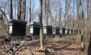
These thirteen slabs are stone samples, from which the primary building material for Grand Central was chosen. The samples were brought to New York City to test how they withstood the elements, though ultimately cost proved to be the deciding factor. Indiana limestone, the second sample in from the south, was chosen because it was the cheapest to transport.

#406 Van Cortlandt Park Trail overpass over Henry Hudson Parkway


Van Cortlandt Park Trail overpass over Henry Hudson Parkway
May 20, 2015, Rob Hickman, Sophie Lrits, Keith Nelson

#405 Van Cortlandt Park Bridal Trail overpass over Henry Hudson Parkway


Van Cortlandt Park Bridal Trail overpass over Henry Hudson Parkway
May 20, 2015, Keith Nelson, Rob Hickman, Sophie Lrits

From Wikipedia:

Van Cortlandt Park is a 1,146-acre (464 ha) park located in the borough of the Bronx in New York City. It is the third largest park in New York City, behind Pelham Bay Park and Staten Island Greenbelt. The park was named for Stephanus Van Cortlandt, who was the first native-born mayor of New York, and the Van Cortlandt family, which was prominent in the area during the Dutch and English colonial periods. Contained within the Park is the Van Cortlandt House Museum, the oldest building in the Bronx. The park is owned by the New York City Department of Parks and Recreation and maintained by the Van Cortlandt Park Conservancy, a private non-profit organization founded in 2009.

There are two nearby New York City Subway stations: the eastern side of the park is served by the Woodlawn subway station (4 train), and the western side by 242nd Street subway station (1 train).

The Wiechquaskeck Lenapes were among the first recorded people to settle in the area now referred to as Van Cortlandt Park. The Lenapes used the geographic features of the area, such as the Tibbetts Brook for fishing and flatland areas for farming, to support their community. The land that Van Cortlandt Park now occupies was purchased by Jacobus Van Cortlandt from John Barrett around 1691. Passed on to his son Frederick Van Cortlandt (1699–1749) and family, it was once a vast grain plantation. In 1748, Frederick built what is now known as the Van Cortlandt House on the property, but died before its completion. Frederick willed the massive home and surrounding lands to his son, James Van Cortlandt (1727–1787).

The Van Cortlandt family land was used during the Revolutionary War by Rochambeau, Lafayette, and Washington. It was in this area that the Stockbridge militia was destroyed by the Queen's Rangers; a stone memorial was placed at "Indian Field" in 1906.

In 1888, the family property was sold to the City of New York and made into a public parkland, with the majority of the grain fields converted into a sprawling lawn dubbed "The Parade Ground". The Van Cortlandt House was converted into a public museum and, with the city's approval, particularly overgrown areas of the property were made passable. Wide walking paths were built over original walkways, including the thin paths that led to the Van Cortlandt family cemetery, high on the nearby bluffs.

In 1907, due to overcrowding, Dr. William Hornaday transferred several of the Bronx Zoo's then-rare bison to Van Cortlandt Park's parade grounds. Later that year, they were shipped to prairie land in Oklahoma.

Robert Moses's development plans in the 1930s called for the construction of the Henry Hudson Parkway and Mosholu Parkway to bisect Van Cortlandt Park and meet at a cloverleaf interchange about half a mile north of the center. The last remaining freshwater marsh in New York City was dredged and landscaped to accommodate construction.

The city's fiscal crisis in the 1970s caused much of the park to fall into disrepair. Gradual improvements began taking place from the late 1980s through the mid-2000s, including the addition of new pathways, signage, and security.

Van Cortlandt Park has numerous attractions and features that are both recreational and educational. The park is home to a free public pool, along with numerous playgrounds for children and areas dedicated for barbecuing. Van Cortldant Park also contains a many areas dedicated to various sports, including baseball, basketball, soccer, cricket, ice skating, fishing and many more. The Van Cortlandt Golf Course, the nation's first public golf course, opened in 1895 and is located centrally on the park grounds. The "Parade Ground" north of the museum in the western part of the park is one of New York's principal cricket fields. The Putnam Trail, an unpaved trail, runs north through the woods to the east of this lawn and west of Van Cortlandt Lake, through the golf course and along Tibbets Brook and the former New York and Putnam Railroad line into Yonkers where it connects to Westchester County's paved South County Trailway. Another bikeway runs east from the golf course's clubhouse to connect to the Mosholu Parkway bike path. The Old Croton Aqueduct Trailway begins in Van Cortlandt Park.

The historic house located in the southern part of Van Cortlandt Park was erected by Frederick Van Cortlandt in 1748. The estate the house sits on was of major importance during the American Revolution. Troops from both the British and Colonial American army rested in this house during the time of war. The Van Cortlandt family owned the property until they decided to sell both the house and land to the City of New York in 1886. Ten years later, the house was restored as a museum displaying the cultural and lifestyle of families in the 18th century. Van Cortlandt Park is a popular site for cross country running owing to its miles of cinder trails and hills. The path surrounding the Parade Grounds, known to runners as the "flats," is 1.37 miles (2.2 km) around. The "back hills" provide a 1.3-mile (2.1 km) loop in the northwestern section of the park. The park was used for the Northeast regional championships of the Foot Locker Cross-Country Championships until 2009 and is used as numerous college championships each fall. The 2.5-mile (4 km) course is used for most high school races, including the Manhattan College Invitational, one of the largest high school cross-country meets in the nation. In 2006, the USA Cross-Country Championships were held at Van Cortlandt and organised by USATF and New York Road Runners. Van Cortlandt Park is also used for many college races and is the home course for Fordham University, Iona College, New York University and Manhattan College (which is located right across the street). The college course is 5 miles (8.0 km). It is used annually for the ICAAAA championships and has hosted the NCAA championships on numerous occasions (attendance about 10,000). It is the home course for the Van Cortlandt Track Club, which started in the late 1970s as a small group of runners meeting for jaunts around the Jerome Park Reservoir in the Bronx. The park is the former home of the Manhattan College Jaspers college baseball team. For the 2015 season, the Jaspers moved to Dutchess Stadium.

#404 Fieldston Road overpass over Henry Hudson Parkway


Fieldston Road overpass over Henry Hudson Parkway
May 20, 2015, Sophie Lrits, Keith Nelson, Rob Hickman

#403 Henry Hudson Parkway East overpass over Henry Hudson Parkway


Henry Hudson Parkway East overpass over Henry Hudson Parkway
May 20, 2015, Keith Nelson, Rob Hickman, Sophie Lrits

#402 West 252nd Street overpass over Henry Hudson Parkway


West 252nd Street overpass over Henry Hudson Parkway
May 20, 2015, Sophie Lrits, Rob Hickman, Keith Nelson

#401 West 246th Street overpass over Henry Hudson Parkway


West 246th Street overpass over Henry Hudson Parkway
May 20, 2015, Sophie Lrits, Rob Hickman, Keith Nelson

#400 Manhattan College Parkway overpass over Henry Hudson Parkway


Manhattan College Parkway overpass over Henry Hudson Parkway
May 20, 2015, Rob Hickman, Keith Nelson, Sophie Lrits

#399 West 239th Street overpass over Henry Hudson Parkway


West 239th Street overpass over Henry Hudson Parkway
May 20, 2015, Sophie Lrits, Keith Nelson, Rob Hickman

#398 Pedestrian Overpass over Henry Hudson Parkway at West 236th Street


Pedestrian Overpass over Henry Hudson Parkway at West 236th Street
May 20, 2015, Rob Hickman, Keith Nelson, Sophie Lrits

#397 West 232nd Street overpass over Henry Hudson Parkway


West 232nd Street overpass over Henry Hudson Parkway
May 20, 2015, Sophie Lrits, Keith Nelson, Rob Hickman

#396 Henry Hudson Parkway overpass over Kapok Street


Henry Hudson Parkway overpass over Kapok Street
May 20, 2015, Sophie Lrits, Keith Nelson, Rob Hickman

#395 Henry Hudson Bridge over Spuyten Duyvil Creek


Henry Hudson Bridge over Spuyten Duyvil Creek
May 20, 2015, Rob Hickman, Sophie Lrits, Keith Nelson

From Wikipedia:

The Henry Hudson Bridge is a steel arch toll bridge in New York City across the Spuyten Duyvil Creek. It connects Spuyten Duyvil in the Bronx with Inwood in Manhattan to the south, via the Henry Hudson Parkway (NY 9A). On the Manhattan side, the parkway goes into Inwood Hill Park. Commercial vehicles are not permitted on this bridge, since commercial vehicles are not accepted on the parkway in general.

The bridge was designed by David B. Steinman, drawing upon his 1911 Ph.D. thesis in civil engineering at Columbia University. Named to commemorate the voyage of Henry Hudson on the Half Moon, which anchored near the site in 1609, it was the longest plate girder arch and fixed arch bridge in the world when it opened in 1936.

The bridge has two roadway levels carrying an aggregate of seven traffic lanes and a pedestrian walkway and spans Spuyten Duyvil Creek just east of where the tidal strait meets the Hudson River. The bridge is part of the Henry Hudson Parkway designated as New York State Route 9A. To its west, at five feet above water level, is the Spuyten Duyvil Bridge, which is used by Amtrak trains heading to Albany, New York and other points north. The Spuyten Duyvil Metro-North station is located under the Henry Hudson Bridge on the Bronx side.

A bridge at this location was proposed as early as 1906, but Spuyten Duyvil residents and other civic groups opposed the bridge, arguing that it would destroy the virgin forest of Inwood Hill Park and bring traffic congestion to the communities on the Bronx side of the river. Meanwhile, Robert Moses preferred the route along the Hudson River because he was able to receive the land to build the Henry Hudson Parkway at no cost and use federal labor to construct the parkway. The construction of the bridge helped open the Riverdale neighborhood to development.

The original single-deck structure was built for the Henry Hudson Parkway Authority by the American Bridge Company at a cost of $4,949,000 and opened to traffic on December 12, 1936. The upper level of the bridge was designed to be added at a later date and opened to traffic on May 7, 1938. The second deck was added an additional cost of approximately $2,000,000, after increasing toll revenues enabled its construction.

The bridge is owned by the City of New York and operated by the MTA Bridges and Tunnels, an affiliate agency of the Metropolitan Transportation Authority. A rehabilitation project commenced in 2000 and is being carried out by Steinman, Boynton, Gronquist and Birdsall a successor firm of Robinson & Steinman, the firm that originally designed and engineered the bridge.

In January 2010, the MTA announced that it planned to implement a pilot program on the Henry Hudson Bridge to phase out toll booths and use open road tolling. In January 20, 2011, this toll pilot project got underway. Drivers without E-ZPass are sent a bill in the mail; the new tolling system was implemented on November 10, 2012.

Starting on March 22, 2015, the cash tolls by mail must pay $5.50 per car or $3.25 per motorcycle. E‑ZPass users with transponders issued by the New York E‑ZPass Customer Service Center pay $2.54 per car or $1.73 per motorcycle. There is no toll to cross by unicycle.

#394 Footbridge over Amtrak Empire Corridor Railroad


Footbridge over Amtrak Empire Corridor Railroad
May 20, 2015, Sophie Lrits, Keith Nelson, Rob Hickman

#393 Hudson River Greenway Overpass over Riverside Drive


Hudson River Greenway Overpass over Riverside Drive
May 20, 2015, Sophie Lrits, Rob Hickman, Keith Nelson

#392 Footbridge at Inwood Hill Park


Footbridge at Inwood Hill Park
May 20, 2015, Rob Hickman, Sophie Lrits, Keith Nelson

#391 Small Bridge at Inwood Hill Park


Small Bridge at Inwood Hill Park
May 20, 2015, Sophie Lrits, Rob Hickman, Keith Nelson

From Wikipedia:
Inwood Hill Park is a city-owned and maintained public park in the Inwood neighborhood of Manhattan, New York City, operated by the New York City Department of Parks and Recreation. It stretches along the Hudson River from Dyckman Street to the northern tip of the island. Inwood Hill Park's densely folded, glacially scoured topography contains the largest remaining forest land on Manhattan Island. Unlike other Manhattan parks, Inwood Hill Park is largely natural, being non-landscaped. As the current name suggests, large areas of the park are hills, mostly wooded.

Inwood Hill Park has a human history that goes back to the Pre-Columbian era. Through the 17th century, Native Americans known as the Lenape inhabited the area. There is evidence of a main encampment along the eastern edge of the park. The Lenape relied on both the Hudson and Harlem Rivers as sources for food. Artifacts and the remains of old campfires were found in Inwood's rock shelters, suggesting their use for shelter and temporary living quarters. Legend has it that under a tulip tree in the park Peter Minuit, Director General of New Netherland, 'purchased' Manhattan from the a band of Native Americans in 1626 for the Dutch West India Company; the purchase price being a shipment of goods worth 60 guilders. The tree, the largest tulip on the island, survived for centuries until it was felled by a storm in 1933. Until the 1950s the base of the tree under which this transaction allegedly took place was still to be seen, surrounded by a large iron fence, but as it rotted it was finally removed and a boulder (Shorakkopoch Rock) and plaque replaced it.

Fort Cockhill, one of many forts built in New York by the Continental Army during the Revolutionary War, stood slightly north from the center of Inwood Hill Park. A small, five-sided earthen structure equipped with two cannons, it overlooked the mouth of Spuyten Duyvil Creek at its confluence with the Hudson River. At the time, the area was known from Colonial to post-Revolutionary War times as Cox's Hill or Tubby Hook Hill.

By the 19th century, what would later be the Inwood Hill Park was the location to country retreats for some of the wealthier families of the community and the rest of New York's social elite. One such notable who had a summer estate in Inwood was Isidor Straus, co-owner of the Macy's department store and a passenger on the ill-fated voyage of the RMS Titanic. The Lords of the Lord & Taylor department store chain owned two mansions built within the park; both mansions were destroyed by fire in the latter part of the 19th century. Additionally, an orphanage was located high on a bluff in what is now Inwood Hill Park in the nineteenth century. The site today includes a small paved area and park benches; no trace of the building remains. At least three freshwater springs arise in the park, one of which was used for drinking water by the workers who constructed the Henry Hudson Bridge.

Between 1915 and the early 1940s, the City purchased some parcels of land that make up the park as it is today. The park was officially opened on May 8, 1926. Many trails were paved over and illuminated with lampposts as a project of the Works Progress Administration during the 1930s. At present, most of these paths and nearly all the lampposts are in dire need of repair.

On September 15, 1995, the Inwood Hill Nature Center was dedicated and opened to the public. It is located near the park entrance on 218th Street and Indian Road. The center is located on Manhattan's only salt-water marsh, and has been designated as an interactive exhibit with ongoing monitoring of the natural area. It is also the focal point to watch the eagles that have been placed in the park to be freed when they are able to adjust to the environment.

The park covers 196.4 acres (79.5 ha). The Henry Hudson Parkway and Amtrak's Empire Connection run through it, and at its northern end the Henry Hudson Bridge and the rail-only Spuyten Duyvil Bridge link Manhattan to the Bronx. Though the park does not support large wild mammals, the local wildlife does include raccoons and skunks as well as the usual city rodents. Both locals and people from outside the neighborhood fish from the riverbank at the north end of the park.

The park's western boundary is the Hudson River, and the southern boundary is 200th Street. From Dyckman Street to 204th Street the eastern boundary is Payson Avenue, from 204th to 214th Street it is Seaman Avenue, and from 215th Street to the park's end at 218th Street the eastern boundary is Indian Road. A number of foot paths criss-cross the park, allowing easy access to Dyckman Street, Fort Tryon Park, and the Riverside Park – part of the Manhattan Waterfront Greenway. Some of these trails are former roads leading to what were once summer estates that later were brought under the control of the city in the creation of the park. Bolton Road, which was the main drive to the Bolton estate, is now the primary pedestrian pathway within the park; its entrance marked by a sign located on Payson Avenue.

Inwood Hill Park is geologically diverse, with marble, schist, and limestone all prevalent in the area. The park is next to the seismologically active Dyckman Street Fault which runs parallel along the southern border of the park. As recently as 1989, activity of this fault caused a magnitude 2 earthquake.

The area of the park along the Harlem River includes one of Manhattan's last remaining natural salt marsh, the other being Smuggler's Cove, which attracts large numbers of waterbirds. These waterfowl can be studied further via educational programs held at the Nature Center at the north end of the property. Mallards, Canada geese and ring-billed gulls are year-round residents, using both the water and the nearby lawns and ballfields. Many wading birds and waterfowl pass through on the spring and fall migrations, and herons and cormorants often spend the summer.

The woods also support a wide variety of birds, including common species such as blue jays and cardinals. Birds of prey that breed in the park include red-tailed hawks and owls. A five-year project that began in summer 2002 is attempting to reintroduce the bald eagle to Manhattan using hacking boxes in the park and eaglets brought in from the Midwest. In the first summer, three of the four introduced eaglets fledged successfully; three or four fledged each year of the program. As of 2007, none had returned to nest in Manhattan, but most of the eagles raised in the park are too young to be nesting.

The lack of green space in the eastern part of Inwood and the Bronx nearby creates an enormous demand for picnicking with barbecues and table/chair setups, activity that is either illegal or tightly controlled in most city parks; however, Inwood Hill Park has managed this by permitting such setups on the manicured, maintained peninsula portion of the park. This has not been without controversy as during the warmer spring and summer months the area becomes unmanageable at times with a lack of policing in the later hours of the day leaving the area open to automobiles, motorcycles and larger open fires in undesignated areas. This is all allowed to happen without regard for safety or for the primal natural surroundings of the area.

The park contains three children's playgrounds, baseball and soccer fields, and tennis and basketball courts. The Inwood Hill Nature Center at the north end of the park is both a location for educational programs and the local headquarters of the Urban Park Rangers. Inwood Hill Park's ballfields are heavily used by local and other city Spanish-language leagues during the long baseball season. It is not uncommon to see hundreds, if not thousands, of uniformed players and spectators at the Dyckman Fields and Seaman Avenue ballpark compounds. This usage places extreme pressure on the park, which, as a result, has required more active management in recent years.

#390 Broadway Bridge over the Harlem River


Broadway Bridge over the Harlem River
May 20, 2015, Rob Hickman, Keith Nelson, Sophie Lrits

From Wikipedia:

The Broadway Bridge in New York City crosses the Harlem River Ship Canal between Inwood on Manhattan Island and Marble Hill, also originally part of the island, but separated from it by the ship canal; it is still part of the borough of Manhattan. The bridge is named because it carries Broadway, which is designated as US 9 here. The bridge also carries the IRT Broadway – Seventh Avenue Line (1 train) above the road. Immediately to the north of the bridge along this line is the Marble Hill – 225th Street station.

Before the Harlem River was rerouted, the bridge in the area was named Kings Bridge, crossing the river on the border between Marble Hill and the Bronx. The Boston Post Road and Albany Post Road crossed this bridge. A later bridge, opened on January 1, 1895, spanned the canal. A total of three bridges spanned the canal at this location. The 1895 bridge, a steam-powered swinging bridge, accommodated only highway and pedestrian traffic. It was replaced in 1905 by a bridge that could accommodate for the extension of the IRT subway line into the Bronx. The 1905 Broadway Bridge was also a swinging bridge, but a second deck was added to allow for subway traffic on the upper deck, and pedestrian and highway traffic on the lower deck.[2] The 1905 iteration of the Broadway Bridge, that was being replaced by a new double-level structure, was reused to create the University Heights Bridge. In June 1906, the old bridge was floated down the river and placed on a newly constructed center pier. After all the approaches and other construction were completed, the new University Heights Bridge opened to traffic on January 8, 1908.

The present Broadway Bridge (opened on July 1, 1962) has a navigable channel 304 feet (93 m) wide providing 136 feet (41 m) of vertical clearance when the bridge is in the open position. In the down position, the bridge provides 24 feet (7.3 m) of vertical clearance.

In 2010, the New York City Department of Transportation, which operates and maintains the bridge, reported an average daily traffic volume in both directions of 37,292. The peak ADT over the Broadway Bridge was 42,555 vehicles in 1990.