Friday, December 18, 2009


Official Tour Cards Now Available
To get your official tour card contact contact Rob rob@hickmanindustries.com or Keith bindle@ix.netcom.com


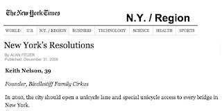
As seen in the New York Times
Read the full article here: http://www.nytimes.com/2010/01/03/nyregion/03resolve.html?th&emc=th


Our December 22nd unicyle expedition was postponed due to a record breaking winter storm.

Wednesday, December 16, 2009

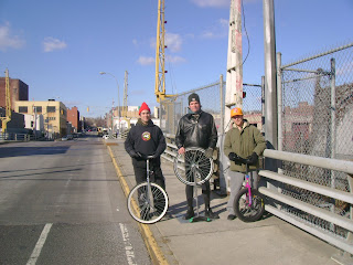
Hamilton Avenue Bridge


Hamilton Avenue Bridge, December 16, 2009
Kyle Petersen on a 20", Rob Hickman on a 24", Keith Nelson on a 26"

The Hamilton Avenue Bridge was our 17th crossing. We got yelled at by the bridge operator for taking pictures. On the way home we went out of our way to ride the 14 block section of Bedford Avenue that recently had it's bike lane removed. The Hassidic community there doesn't like bicyclists. But they love seeing people ride unicycles. So do construction workers.


From the New York City Department of Transportation:

The Hamilton Avenue Bridge is a bascule type bridge with two parallel leafs, one carrying the northbound roadway and the other carrying the southbound roadway. Most of the length of Hamilton Avenue runs below the elevated portion of the Gowanus Expressway, including the bridge. The bridge connects Smith Street and Second Avenue over the Gowanus Canal and is the first canal crossing north of the Gowanus Bay. The Department of Transportation has reconstructed the Hamilton Avenue Bridge, which was built in 1942. The new bridge features all-new mechanical and electrical operating systems, an improved fender system and navigation lighting for marine traffic, wider traffic lanes, and other improvements. The cost of the reconstruction was over $55 million.

Ninth Street Bridge


Ninth Street Bridge, December 16, 2009
Keith Nelson on a 26", Rob Hickman on a 24", Kyle Petersen on a 20"

With the Ninth Street Bridge comes the realization that each of the Gowanus Bridges have their own character. The Ninth Street Bridge has one of those industrial beauties that you can find only in the older nooks of New York. The steel structures soaring over this bridge move the subway above. And all of this beauty is doubled by the mirrored reflection on the green waters of the Gowanus.

From the New York City Department of Transportation:

The new lift bridge replaces a bascule span that was in an advanced state of deterioration. The new structure provides an improved wider channel in the canal for unobstructed vessel passage. The bridge has state-of-the-art electronically controlled lifting machinery that should provide 50 years of reliable service. The bridge carries 3 lanes of traffic; 2 lanes westbound and 1 eastbound.

#15 Third Avenue Bridge at Fifth Street Basin


Third Avenue Bridge, December 16, 2009
Keith Nelson on a 26", Rob Hickman on a 24", Kyle Petersen on a 20"

After a thorough analysis, we have decided that this was in fact a bridge. It looked like a bridge. There was water underneath it. And there were guard rails on both sides. The problem was that there were no signs or plaques. In the New York City Department of Transportation database there is mention of a Third Avenue Bridge in Brooklyn at Fifth Street Basin. This must be it.

#14 Third Street Bridge


Third Street Bridge, December 16, 2009
Kyle Petersen on a 20", Rob Hickman on a 24", Keith Nelson on a 26"

From the New York City Department of Transportation:

The Third Street Bridge is a double-leaf Scherzer rolling lift bascule, supporting Third Street over the Gowanus Canal in the Borough of Brooklyn. It supports two vehicular traffic lanes, each approximately 16 feet wide, and two sidewalks, each six feet wide. Initially constructed around 1905, the bridge was comprehensively rehabilitated in 1986. This included new mechanical and electrical equipment, and a partial structural rehabilitation

#13 Carroll Street Bridge


Carroll Street Bridge, December 16, 2009
Keith Nelson on a 26", Rob Hickman on a 24", Kyle Petersen on a 20"

From the New York City Department of Transportation:

The Carroll Street Bridge is a retractile bridgecrossing the Gowanus Canal in the borough of Brooklyn, New York City. The bridge, which was opened to traffic in 1889, supports a 17 foot wide roadway and two 4.5 foot sidewalks.

#12 Union Street Bridge


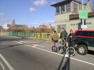
Union Street Bridge, December 16, 2009
Kyle Petersen on a 20", Rob Hickman on a 24", Keith Nelson on a 26"

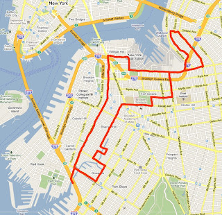
On a cold winter's morning we set out for the Gowanus Canal, a 10 mile roundtrip from our starting point. The Gowanus Canal bisects the communities of Carroll Gardens, Gowanus, Park Slope, and Redhook, and extends 1.8-miles from to the Gowanus Bay Channel in the New York Harbor. Five east-west movable-bridges cross the canal starting with Union Street, Carroll Street, Third Street, 9th Street and Hamilton Avenue.


From the New York City Department of Transportation:

The Union Street Bridge is a double leaf Scherzer rolling lift bascule supporting Union Street over the Gowanus Canal in the borough of Brooklyn. The bridge has two vehicular traffic lanes, each approximately 17 feet wide, and two sidewalks, each 6 feet wide. Both traffic lanes carry eastbound traffic.

Tuesday, December 8, 2009

#11 Metropolitan Avenue Bridge


Metropolitan Avenue Bridge December 8, 2009
Rob Hickman on a 24" and Keith Nelson on a 26"

The Metropolitan Avenue Bridge, over English Kills and on route to the Grand Street bridge was two and a half miles from our starting point and our 12th bridge. When we approached the bridge and saw the gates down, we thought we were going to encounter our first open bridge. We realized, though, they were just testing the gates.

From the New York City Department of Transportation:

Metropolitan Avenue is a two-way local City street in Kings and Queens Counties. The number of lanes varies from two to four along the entire length of Metropolitan Avenue, which runs east-west and extends from River Street in the Southside section of Brooklyn to Jamaica Avenue in Queens. The bridge, the only one over English Kills, carries both Metropolitan Avenue and Grand Street. The bridge is situated between Vandervoort and Varick Avenues in the East Williamsburg section of Brooklyn. The Metropolitan Avenue Bridge is a double leaf bascule bridge with a span of 33.8 m. The general appearance of the bridge has been significantly changed since it was opened in 1931. The bridge provides a channel with a horizontal clearance of 26.2 m and a vertical clearance, in the closed position, of 3.0 m at MHW and 4.6 m at MLW. The bridge structure carries a four-lane two-way vehicular roadway with sidewalks on either side. The roadway width is 16.2 m and the sidewalks are 1.8 m. There are no height restrictions on the bridge.

After the City acquired Metropolitan Avenue from the Williamsburg and Jamaica Turnpike Road Company in 1872, the existing bridge was replaced by a swing bridge, which was also used by the Broadway Ferry and Metropolitan Avenue Railroad Company. Growth in the area made the bridge inadequate by the early 20th century. The current bridge was built in 1931. Modifications since then have included upgrading the mechanical and electrical systems and the replacement of deck, bridge rail, and fenders. The stringers were replaced and new stiffeners added in 1992.

#10 Grand Street Bridge


Grand Street Bridge December 8, 2009
Rob Hickman on a 24" and Keith Nelson on a 26"

The Grand Street Bridge, over the east branch of Newtown Creek and a six mile round trip ride from our starting point, was our 13th bridge. It was our first 'swing' - type bridge and the most poorly maintained deck to date.

From the New York City Department of Transportation:

Grand Street is a two-lane local City street in Queens and Kings Counties. Grand Street runs northeast and extends from the Brooklyn Queens Expressway in Brooklyn to Queens Boulevard in Queens. The road is known as Grand Street west of the bridge and Grand Avenue east of the bridge. The bridge is located between Gardner Avenue in Brooklyn and 47th Street in Queens. The Grand Street Bridge is a 69.2m long swing type bridge with a steel truss superstructure. The general appearance of the bridge remains the same as when it was opened in 1903. The bridge provides a channel with a horizontal clearance of 17.7m and a vertical clearance, in the closed position, of 3.0m at MHW and 4.6m at MLW. The bridge structure carries a two-lane two-way vehicular roadway with sidewalks on either side. The roadway width on the bridge is 6.0m and the sidewalks are 1.8m wide. The height restriction is 4.1m. The approach roadways are wider than the bridge roadway. For example, the width of Grand Avenue at the east approach to the bridge (near 47th Street) is 15.11m.

The first bridge on this site, opened in 1875, quickly became dilapidated due to improper maintenance. Its replacement, opened in 1890, was declared by the War Department in 1898 to be "an obstruction to navigation." Following a thorough study, a plan was adopted in 1899 to improve the bridge and its approaches. The current bridge was opened on February 5, 1903 at a cost of $174,937.

Saturday, December 5, 2009

#9 Hunters Point Avenue Bridge


Hunters Point Avenue Bridge, December 3, 2009
Rob Hickman on a 24" and Keith Nelson on a 26"

The Hunters Point Avenue Bridge, over Dutch Kills, was a six mile round trip ride from our starting point, and our 11th bridge. On the way we passed the Borden Avenue bridge, also over Dutch Kills, which is currently under construction. We plan to return as soon as work is finished.

From the New York City Department of Transportation:

Hunters Point Avenue is a two-lane local City street in Queens. Hunters Point Avenue is oriented east-west and extends from 21st Street to the Long Island Expressway/Brooklyn Queens Expressway interchange in Queens. The avenue is parallel to and approximately one block south of the Long Island Expressway. The Hunters Point Bridge over Dutch Kills is situated between 27th Street and 30th Street in the Long Island City section of Queens, and is four blocks upstream of the Borden Avenue Bridge. It is a bascule bridge with a span of 21.8m. The general appearance of the bridge has been significantly changed since it was first opened in 1910. The bridge provides a channel with a horizontal clearance of 18.3m and a vertical clearance, in the closed position, of 2.4m at MHW and 4.0m at MLW. The bridge structure carries a two-lane, two-way vehicular roadway with sidewalks on either side. The roadway width is 11.0m, while the sidewalks are 1.8m wide. The width of the approach roadways vary from the width of the bridge roadway. The west approach and east approach roadways are 13.4m and 9.1m, respectively.

The first bridge at this site, a wooden structure, was replaced by an iron bridge in 1874. That bridge was permanently closed in 1907 due to movement of the west abutment, which prevented the draw from closing. It was replaced in 1910 by a double-leaf bascule bridge, designed by the Scherzer Rolling Lift Bridge Company. The bridge was rebuilt in the early 1980's as a single-leaf bascule, incorporating the foundations of the previous bridge.

#8 Greenpoint Avenue Bridge aka John Jay Byrne Memorial Bridge


Greenpoint Avenue Bridge aka John Jay Byrne Memorial Bridge, December 3, 2009
Keith Nelson on a 26" and Rob Hickman on a 24"

The Greenpoint Avenue Bridge over Newtown Creek was a two and a half mile ride from our starting point. Here we broke double digits.

From the New York City Department of Transportation:

Greenpoint Avenue aka John Jay Byrne Memorial Bridge is a four-lane local City street in Queens and Kings Counties. Greenpoint Avenue runs northeast and extends from West Street (East River) in Greenpoint, Brooklyn and turns into Roosevelt Avenue in Sunnyside, Queens. The Greenpoint Avenue Bridge, also known as the J. J. Byrne Memorial Bridge, is located approximately 2.2km from the mouth of Newtown Creek. The bridge is situated between Kingsland Avenue in Greenpoint, Brooklyn and Review Avenue in the Blissville section of Queens. The Greenpoint Avenue Bridge is a double-leaf trunnion bascule, with 21.3m wide leaves. This bridge is a steel girder structure with a filled grid deck. The bridge provides a channel with a horizontal clearance of 45.4m and in the closed position a vertical clearance of 7.9m at MHW and 9.4m at MLW. The bridge structure carries a four-lane two-way vehicular roadway with a 1.2m striped median and sidewalks on either side. The roadway width is 8.6m and the sidewalks are 4.0m and 3.7m for the north and south sidewalk respectively. The approach roadways are narrower than the bridge roadway. The west approach and east approach roadways are 17.1m (including 1.4m center median) and 11.9m respectively.

The first bridge on this site, a drawbridge known as the Blissville, was built in the 1850's. It was succeeded by three other bridges before a new one was completed in March 1900 at a cost of $58,519. That bridge received extensive repairs after a fire in 1919 damaged parts of the center pier fender, the southerly abutment, and the superstructure. Until that time, the bridge had also carried tracks of the Long Island Rail Road. The current bridge was built in 1987.
From Wikipedia: The Greenpoint Avenue Bridge is a drawbridge that carries Greenpoint Avenue across Newtown Creek between Greenpoint, Brooklyn and Blissville, Queens. Greenpoint Avenue continues eastward into Queens where it connects to Roosevelt Avenue.

Also known as the J. J. Byrne Memorial Bridge, the bridge is named after James J. Byrne, who served as Brooklyn Borough President from September 1926 until he died in office on March 14, 1930. Previously, Byrne was the Brooklyn Commissioner of Public Works.
From Queens
The Greenpoint Avenue Bridge is the sixth bridge to cross Newtown Creek in this location. In the 1850s, Neziah Bliss built the first drawbridge, which was called the Blissville Bridge. It was followed by three other bridges before being replaced by a new bridge in March 1900. A new bridge opened in 1929 and after suffering from mechanical problems it was replaced by the current structure in 1987.
Designed by Hardesty & Hanover, the Greenpoint Avenue Bridge was the recipient of an American Institute of Steel Construction Award in 1991.
On March 30, 2009, New York City Mayor Michael Bloomberg held a press conference at the Greenpoint Avenue Bridge, announcing that it would receive $6 million in federal stimulus funds, which will be used to rehabilitate the bridge.

#7 Ward's Island Bridge


Ward's Island Bridge, November 25, 2009
Keith Nelson on a 26", Kyle Petersen on an 20", Rob Hickman on a 24"

From Wikipedia:

The Ward's Island Bridge, also known as the 103rd Street Footbridge, is a pedestrian bridge crossing the Harlem River between Manhattan Island and Ward's Island in New York City. The vertical lift bridge has a total of twelve spans consisting of steel towers and girders. It is unique among the city's Harlem River crossings in that it only carries pedestrian, bicycle, and unicycle traffic.

On the Manhattan side of the river, the bridge is located at East 103rd Street, between Exits 14 and 15 of the FDR Drive. The bridge is accessible from the East River Esplanade and a pedestrian overpass across the FDR Drive to the East River Houses apartment complex in Spanish Harlem. The bridge connects to the southwestern corner of Ward's Island and provides access to the the many playing fields and scenic waterfront of Randall's and Ward's Island Park.

The Ward's Island Bridge is available for use from April through October during daylight hours. During the months from November through March, the bridge is kept in the "open" position and cannot be accessed.

History:

he first known bridge to Ward's Island was a wooden drawbridge between East 114th Street in Manhattan to the northwest corner of the island. The bridge was built in 1807 to serve a cotton business run by Philip Milledolar and Bartholomew Ward and lasted until 1821, when it was destroyed by a storm. Pedestrian access to Randall's and Ward's Islands was established with the opening of the Triborough Bridge by the Triborough Bridge and Tunnel Authority in 1936. Although plans to construct a separate pedestrian bridge to provide Manhattan residents better access to the new Ward's Island's Park were developed by Robert Moses in 1937, construction of the bridge did not begin until 1949. Designed by Othmar Hermann Ammann, the footbridge was originally known as the Harlem River Pedestrian Bridge. The bridge was built by the Triborough Bridge and Tunnel Authority and given to New York City.

The Wards Island Bridge opened to pedestrians on May 18, 1951 and was completed at a cost of $2.1 million. The bridge was later opened to bicycles in 1967. Although the bridge was originally painted in a red, yellow, and blue color scheme, it was repainted in sapphire blue and emerald green in 1986. Restricting access to the bridge during the overnight hours and winter months traces back to concerns from residents of the East River Houses in the 1980s and 1990s over patients from the Manhattan State Psychiatric Center who frequently crossed the bridge into Manhattan. Tenants believed that the patients were responsible for increased levels of crime in their neighborhood.

In 1999, the New York City Department of Transportation proposed that the bridge be converted to a fixed bridge status. However, this proposal was delayed due to the clearance necessary to float construction equipment up the Harlem River for reconstruction projects associated with the Third Avenue, Willis Avenue, and 145th Street Bridges. The Wards Island Bridge is scheduled to undergo reconstruction between April 2010 and April 2012, which will include replacement of the walkway deck, steel superstructure, and electrical and mechanical control systems.

#6 Robert F. Kennedy Bridge (Triborough Bridge)


Robert F. Kennedy Bridge (Triborough Bridge), November 25, 2009
Kyle Petersen on an 20", Keith Nelson on a 26", Rob Hickman on a 24"

View on Unicycle NYC Bridge Tour Map at: unibridgetour.net

On a chilly November morning drenched with fog, we set out to cross Robert Moses's infamous Triborough bridge. The Triborough consists of three spans. The first and longest goes from Astoria Queens to Randalls island, high up over Hell Gate- where Long Island Sound meets the East River. The second span bridges the trickling Bronx Kill and a series of railroad tracks between Randall's Island and the Bronx. The third span goes from Randall's Island to Manhattan, crossing the Harlem River. We had a difficult time finding the unicycle path for this section. Worth noting was the team of construction workers who enjoyed our shenanigans on the first span. The handrail on this section was particularly low, adding vertigo to the challenge. In addition to the Triborough, we enjoyed a lovely pedal along the East River down to and across the narrow Randall's Island pedestrian bridge.


From Wikipedia:

The Robert F. Kennedy Bridge better known as the Triborough Bridge is a complex of three separate bridges in New York City. Spanning the Harlem River, the Bronx Kill, and the Hell Gate (part of the East River), the bridges connect the boroughs of Manhattan, Queens, and The Bronx via Randall's Island and Ward's Island, which are joined by landfill. Often historically referred to as simply the Triboro, the spans were officially named after Robert F. Kennedy in 2008.

Plans for connecting Manhattan, Queens and the Bronx were first announced by Edward A. Byrne, chief engineer of the New York City Department of Plant and Structures, in 1916. While its construction had been long recommended by local officials, the Triborough Bridge did not receive any funding until 1925, when the city appropriated funds for surveys, test borings and structural plans. Construction had begun on Black Friday in 1929, and the Triborough project's outlook began to look bleak. Othmar Ammann's assistance was enlisted to help simplify the structure. Ammann had collapsed the original two-deck roadway into one, requiring lighter towers, and thus, lighter piers. These cost-saving revisions saved $10 million on the towers alone. Using New Deal money, the project was resurrected in the early 1930s by Robert Moses and the bridge was opened to traffic on July 11, 1936. Its cost was greater than that of the Hoover Dam. The structure used concrete from factories from Maine to Mississippi. To make the formwork for pouring the concrete, a whole forest in Oregon was cut down.

The bridge is owned by the City of New York and operated by the Triborough Bridge and Tunnel Authority (TBTA), an affiliate agency of the Metropolitan Transportation Authority (New York). At some point in the past, a sign on the bridge informed travelers, "In event of attack, drive off bridge", New York Times columnist William Safire wrote in 2008. The "somewhat macabre sign", he wrote, must have "drawn a wry smile from millions of motorists." On November 19, 2008, and pursuant to a request made by the Kennedy family, the Triborough Bridge was officially renamed after Robert F. Kennedy, who served New York as a senator, 40 years after his assassination. Since then, the term RFK-Triborough has become increasingly popular as a nickname for the bridge, with typical traffic reports using the name.

The toll revenues from the Robert F. Kennedy Bridge pay for a portion of the public transit subsidy for the New York City Transit Authority and the commuter railroads. The bridge carries approximately 200,000 vehicles per day. The bridge has sidewalks in all three legs where the TBTA officially requires bicyclists to walk their bicycles across due to safety concerns. However, the signs stating this requirement have been usually ignored by bicyclists, while the New York City Government has recommended that the TBTA should reassess this kind of bicycling ban. Stairs on the 2 km (1.3 mile) Queens leg impede handicapped access. The Queens stairway along the southern side was demolished at the beginning of the 21st century, thus isolating that walkway, but the ramp of the Wards Island end of the walkway along the northern side was improved in 2007. The two sidewalks of the Bronx span are connected to only one ramp at the Randalls Island end. The Triborough Bridge and Tunnel Authority announced a toll increase on its facilities, effective March 16, 2008. The cash charge for passenger vehicles to cross the Triborough raised to $5.00 (from $4.50) in any direction. The toll for E-ZPass users raised to $4.15 (from $4.00). The crossing charge for a motorcycle raised to $2.25 (from $2.00), with motorcycle E-ZPass tolls rising to $1.81 (from $1.75). The return trip from Randall's Island to any borough is free. The Triborough Bridge and Tunnel Authority announced a toll increase on its facilities, effective July 12, 2009. The cash charge for passenger vehicles to cross the Triborough raised to $5.50 (from $5.00) in any direction. The toll for New York State E-ZPass users raised to $4.57 (from $4.15). The crossing charge for a motorcycle raised to $2.50 (from $2.25), with motorcycle tolls with a New York State E-ZPass rising to $1.99 (from $1.81). No discount is provided for out-of-state E-ZPasses. The return trip from Randall's Island to any borough is free.

The three sections of the bridge:

East River suspension bridge (I-278)
Span crosses the East River at the Hell Gate between Queens and Ward's Island
Connects to Grand Central Parkway and Brooklyn-Queens Expressway
Length of main span: 1,380 feet (421 m)
Length of each side span: 700 feet (213 m)
Length, anchorage to anchorage: 2,780 feet (847 m)
Width of bridge: 98 feet (30 m)
Number of traffic lanes: 8 lanes
Height of towers above mean high water: 315 feet (96 m)
Clearance at center above mean high water: 143 feet (44 m)
Number of sidewalks: 1

Harlem River lift bridge (NY Reference Route 900G)
Span crosses the Harlem River between Manhattan and Randall's Islands
Connects to Harlem River Drive, FDR Drive, and 125th Street
Length of main lift-truss span: 310 feet (94 m)
Length of each side truss span: 230 feet (70 m)
Length, anchorage to anchorage: 770 feet (235 m)
Height of towers: 210 feet (64 m)
Clearance of lift span above mean high water: 55 feet (17 m)
Clearance of lift span in raised position: 135 feet (41 m)
Number of traffic lanes: 6 lanes
Number of sidewalks: 2 (1 on each side)

Bronx Kills crossing (I-278)
Span crosses the Bronx Kill between The Bronx and Randall's Island
Connects to Major Deegan Expressway and Bruckner Expressway
Length of main truss span: 383 feet (117 m)
Length of approach truss span: 1,217 feet (371 m)
Length, anchorage to anchorage: 1,600 feet (488 m)
Clearance of truss span above mean high water: 55 feet (17 m)
Number of traffic lanes: 8 lanes
Number of sidewalks: 2 (1 on each side)

#5 Pulaski Bridge


Pulaski Bridge, November 18, 2009
Keith Nelson on a 26", Kyle Petersen on an 20", Rob Hickman on a 24"

From the New York City Department of Transportation:

The Pulaski Bridge, which carries six lanes of traffic and a pedestrian sidewalk over Newton Creek and the Long Island Expressway, is orientated north-south and connects Greenpoint in Brooklyn to Long Island City in Queens. McGuinness Boulevard approaches the bridge from the south and Eleventh Street from the north. The Pulaski Bridge is a 54m double leaf, trunnion type bascule bridge. It has two 10.5m roadways divided by a concrete median barrier. It also carries a 2.7m pedestrian sidewalk. The bridge provides a channel with a horizontal clearance of 45.7m and a vertical clearance of 11.9m in the closed position at MHW and 13m MLW.

The Pulaski Bridge was opened to traffic on September 10, 1954. The bridge was reconstructed in 1994 at a cost of approximately $40 million. The project included new approach roadways, new superstructure and approach spans, and upgrade of the bridge's mechanical/electrical systems.

#4 Ed Koch Queensboro Bridge AKA 59th Street Bridge


Ed Koch Queensboro Bridge AKA 59th Street Bridge, November 4, 2009
Rob Hickman on a 24" and Keith Nelson on a 24"

From the New York City Department of Transportation:

Originally christened Blackwell’s Island Bridge, and intended to link Manhattan’s Harlem Line with the Long Island Railroad, the colossal, two-decked Queensboro Bridge is one of the greatest cantilever bridges in the history of American bridge design. A collaboration between the famed bridge engineer Gustav Lindenthal (1850-1935) and architect Henry Hornbostel, the Queensboro’s massive, silver-painted trusses span the East River between 59th Street in Manhattan and Long Island City in Queens and offer spectacular views of midtown Manhattan, highlighted by the Empire State Building, the Chrysler Building, and the United Nations. Often referred to as the 59th Street Bridge, the Queensboro’s completion preceded that of the Manhattan Bridge by nine months. The bridge has been immortalized by numerous artists and musicians, including Simon & Garfunkel in their hit song, "The 59th Street Bridge Song/Feelin’ Groovy."

Statistics:
Construction commenced - July 19, 1901
Open to traffic - March 30, 1909
Total length of bridge and approaches - 7449 feet

#3 Brooklyn Bridge


Brooklyn Bridge, October 29, 2009
Rob Hickman on a 24" and Keith Nelson on a 24"

After a ride around the cobblestone streets of DUMBO, we went up and over the Brooklyn Bridge to City Hall in Manhattan. Despite fears of difficult wood planking and aggressive German tourists, the span was surely the easiest and most pleasant of all our East River crossings. This was bridge number three.

From the New York City Department of Transportation:

Arguably the most influential bridge in American history, the Brooklyn Bridge remains one of New York City’s most celebrated architectural wonders. Designed by the brilliant engineer John Augustus Roebling (1806-1869) and completed by his equally ingenious son Washington Roebling (1837-1926), this elegant structure was, at the time of its completion in 1883, the longest suspension bridge in the world. Anchored across the lower East River by two neoGothic towers and a delicate lacework of steel-wire cables, the soaring lines of the Brooklyn Bridge have inspired countless architects, engineers, painters and poets to pursue their own expressions of creative excellence, among them Frank Lloyd Wright, Hart Crane, Walt Whitman, Georgia O'Keefe, Joseph Stella, John Marin and Lewis Mumford.

Statistics:
Construction Commenced - January 3, 1870
Opened to traffic - May 24, 1883
Total length - 6016 feet
Length of Main Span - 1595.5 feet
Length of each of the four cables - 3578.5 feet

#2 Manhattan Bridge


Manhattan Bridge, October 21, 2009
Rob Hickman on a 24" and Keith Nelson on a 24"

The Manhattan Bridge was our second crossing. It was a six mile roundtrip from our starting point. We took the north bridge path into Manhattan and the south path back to Brooklyn.

From the New York City Department of Transportation:

The youngest of the three NYCDOT maintained suspension bridges that span the East River, the Manhattan Bridge was designed by Leon Moisseiff (1872-1943) and completed in 1909. Fitted with a splendid set of approaches designed by the renowned architectural team of Carrere and Hastings, the Manhattan Bridge is one of the most aesthetically pleasing of New York City's transportation structures.

Daily, the bridge accommodates some 75,000 vehicles, 320,000 mass transit riders and 3000 pedestrians/bicyclists/unicyclists between Manhattan and Brooklyn. It supports seven lanes of vehicular traffic as well as four subway tracks upon which four transit train lines operate.

Statistics:
Construction commenced - October 1, 1901
Open to Traffic - December 31, 1909
Total length - 6855 feet
Length of main span - 1470 feet
Length of each of the four cables - 3224 feet

#1 Williamsburg Bridge


Williamsburg Bridge, October 14, 2009
Keith Nelson on a 24" and Rob Hickman on a 24"

View on Unicycle NYC Bridge Tour Map at: unibridgetour.net

Both of us live just a few block from the base of the Williamsburg bridge. One day we decided to unicycle across it. Afterwards we decided to ride to McCarren park and back. Somewhere during that ride we decided to ride our unicycles across every bridge in New York City. And thus our mission was forged.

From the New York City Department of Transportation:

Said to have been inspired by the works of the eminent French architect Alexandre Gustave Eiffel, the landmark Williamsburg Bridge is the largest of the three suspension bridges that span the heavily-navigated East River. A gargantuan structure noted for its 35-story steel towers and ponderous stiffening trusses, the Williamsburg Bridge boldly reaches from Delancey Street on the Lower East Side of Manhattan to Marcy Avenue in Williamsburg, Brooklyn. Designed by Leffert L. Buck and architecturally embellished by Henry Hornbostel, the bridge took seven years and $30 million to construct. Upon its completion in 1903, it became the longest suspension bridge in the world, supplanting a record held by the Brooklyn Bridge for the previous two decades. The first elevated train went into service on the bridge in 1905.

Statistics:
Construction commenced - November 7, 1896
Open to traffic - December 19, 1903
Total Length - 7308 feet
Length of the main span - 1600 feet
Length of each of the four cables - 2985 feet